
2018年8月18日雅思大作文预测:地图题
题型3 话题分类:地图 属性:一级重点
参考题目1
The map below is of the town of Garlsdon. A new supermarket (S) is planned for the town. The map shows two possible sites for the ...
The map below is of the town of Garlsdon. A new supermarket (S) is planned for the town. The map shows two possible sites for the supermarket. Summarise the information by selecting and reporting the main features, and make comparisons where relevant. You should write at least 150 words. Allow yourself 20 minutes for this task.
图片
解题思路
【首段】分述选址1的地理位置 【二段】分述选址2的地理位置 【尾段】对于Cransdon, Hindon 和 Garlsdon的人来说选址1的好处更多
范文
The first potential location (S1) is outside the town itself, and is sited just off the main road to the town of Hindon, lying 12 kms to the north-west. This site is in the countryside and so would be able to accommodate a lot of car parking. This would make it accessible to shoppers from both Hindon and Garlsdon who could travel by car. As it is also close to the railway line linking the who towns to Cransdon (25 km to the south-east), a potentially large number of shoppers would also be able to travel by train. In contrast, the suggested location, S2, is right in the town centre, which would be good for local residents. Theoretically the store could be accessed by road or rail from the surrounding towns, including Bransdon, but as the central area is a no-traffic zone, cars would be unable to park and access would be difficult. Overall, neither site is appropriate for all the towns, but for customers in Cransdon, Hindon and Garlsdon, the out-of-town site (S1) would probably offer more advantages.
参考题目2
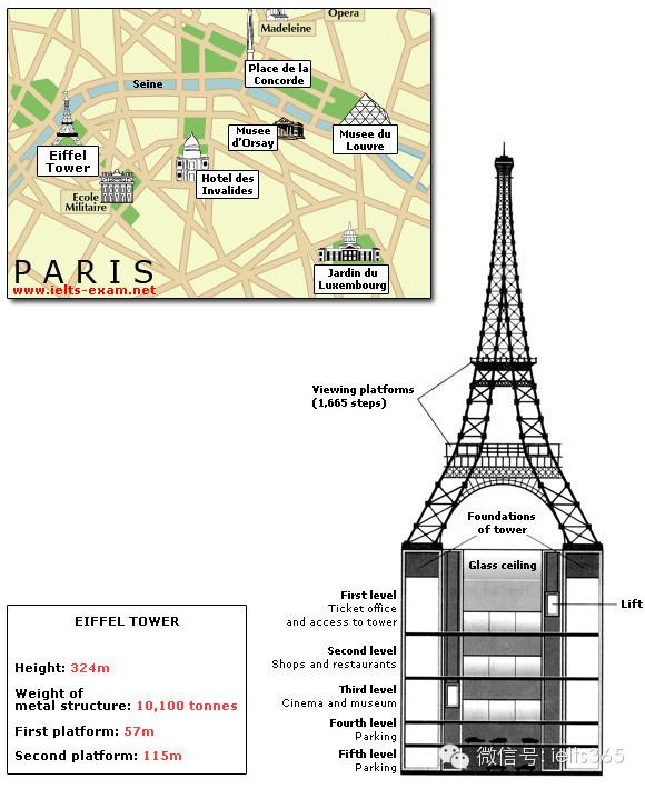
The diagrams below give information about the Eiffel Tower in Paris and an outline project to extend it underground. Write a repor...
The diagrams below give information about the Eiffel Tower in Paris and an outline project to extend it underground. Write a report for a university lecturer describing the information shown. You should write at least 150 words. You should spend about 20 minutes on this task.
图片
解题思路
【首段】总述埃菲尔铁塔的地理位置 【二段】分述申请批准计划报告这四个步骤 【三段】分述地下要建造售票处购物设施影院博物馆和停车场 【尾段】分述地下要建造乘客电梯和玻璃天花板
范文
The Eiffel Tower is situated close to the Seine River in Paris. It is a metal structure that is 1,063 feet high and weighs 7,417 tonnes. The tower has been a tourist attraction since 1889, when it was built, and there are 1,665 steps that can be climbed in order to reach the two viewing platforms. There are now plans to build below the foundations of the tower. These plans include the development of five underground levels that will incorporate the tower's ticket office, shopping facilities, a cinema and museum and two floors of underground parking. Although details have yet to be finalised, the principle is that the five floors will be connected by two vertical passenger lifts on either side of the tower. In addition, the floor immediately below the tower, which is planned to house the ticket office, will also consist of a large atrium with a glass ceiling so that visitors can look directly up at the tower itself.
参考题目3
The plans below show the South Wing of Walton Museum in 2008 and in 2012 after it was redeveloped.
图片

解题思路
【首段】总述图表显示博物馆南边从2008到2012年的变化 【二段】分述2008年博物馆南边的情况 【尾段】分述2012年博物馆南边的情况
范文
The maps reveal the change of the South Wing of Walton Museum in the period of 2008 to 2012. In 2008, the South Wing was a two-storey building with a path on the west. On the ground floor, there was a special exhibition room, a shop and a cloaks room. The reception was on the first floor, and there was also a reading room next to the reception. Visitors can take the stairs between the shop and the cloaks room to the ground floor. By the year 2012, the building had four floors with a life from the ground floor to the top floor. Children play area had replaced the cloaks room and the cloaks room had been moved to the reception. On the eastern side of the lift, there was a new cafe where visitors can serve themselves and on the top floor was another exhibition room. Opposite to the cafe was a new-built restaurant. In the west of the building, an entrance hall was constructed on the first floor and it should be noted that on the second floor there was a terrace.
参考题目4
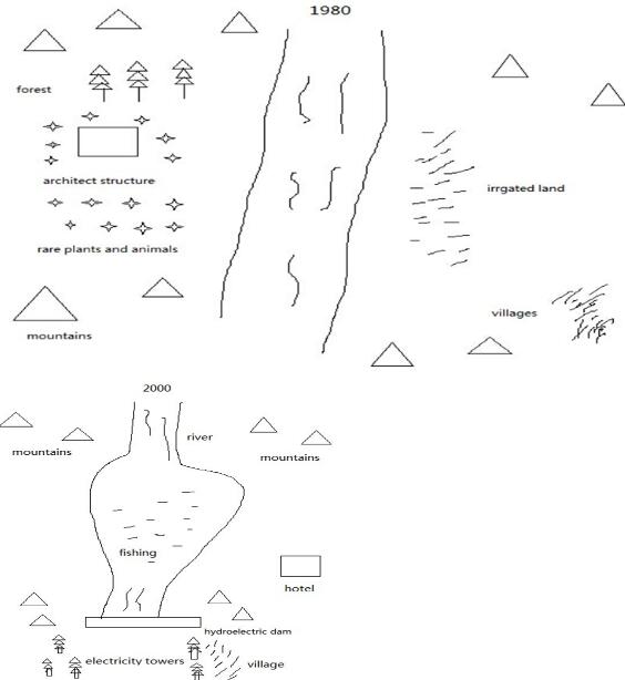
The maps show the change of a place in 1980 and in 2000.
图片
解题思路
【首段】总述图表显示某地建立水电站前后的变化 【二段】分述1980年某地情况 【三段】分述2000年某地情况 【尾段】总述某地建立水电站前后变化很大
范文
The two maps reveal the change of a place, before and after the construction of hydroelectric dam. In 1980, there was a river flowing from north to south among mountains. On the right bank of the river, the irrigated land was scattered along the river, with villages on its right side. On the left side of the river, there was a forest, which was situated to the north of some structures. Meanwhile, some rare plants and animals can be found around the architectures. After two decades, this place experienced a significant shift. Firstly, the woods on the left side of the river were deforested and the buildings nearby were completely removed. Besides, the irrigated land was replaced by a hotel and the villages moved to the southeast of the river, sited to the east of some newly-built electricity towers. What’s more, a large hydroelectric dam was constructed in the south of the river, so the rivers was enlarged and became a fishing lake. All in all, this place has changed significantly after the hydroelectric dam was built.
参考题目5
The diagrams below show how houses can be protected in areas which are prone to flooding.
图片

解题思路
【首段】总述图表比较两种保护房子防洪方法 【二段】总述无论是否有防洪堤都能让处于危险的房子在地面之上 【三段】分述有防洪堤时保护房子的方法 【尾段】分述没有防洪堤时保护房子的方法
范文
The diagrams compare two different methods of defence for homes which are at risk of being flooded. The key difference between the diagrams is that they show flood protection with and without a stopbank. In either case, the at-risk home is raised on stilts above ground level. The first diagram shows how a stopbank acts as a flood barrier to stop river water from flooding homes. The stopbank is a small mound of land next to the river that is higher than the 100-year flood level, and prevents the river from bursting its banks. Nearby houses can be built on stilts to prevent flooding from rainwater, and a floodgate beneath the stopbank can be opened to allow this ‘ponding’ to drain off into the river. When there is no stopbank, as shown in the second diagram, there will be nothing to stop the river from flooding. In this case, the solution is to put buildings on stilts. The height of the stilts is measured so that the floor of the house is 300mm above the 100-year flood level. This measurement is called the ‘freeboard’.
参考题目6
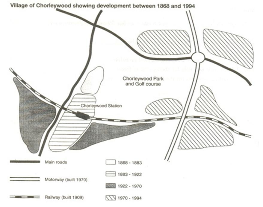
The map shows the development of the village of Chorleywood between 1868 and 1994.
图片
解题思路
【首段】总述图表显示Chorleywood从1868到1994年间的变化 【二段】总述在四个时间段里交通基础设施不断进步 【三段】分述1868-1883以及1883-1922两个时间段内交通进步 【尾段】分述1922-1970以及1970-1994两个时间段内交通进步
范文
The map shows the growth of a village called Chorleywood between 1868 and 1994. It is clear that the village grew as the transport infrastructure was improved. Four periods of development are shown on the map, and each of the populated areas is near to the main roads, the railway or the motorway. From 1868 to 1883, Chorleywood covered a small area next to one of the main roads. Chorleywood Park and Golf Course is now located next to this original village area. The village grew along the main road to the south between 1883 and 1922, and in 1909 a railway line was built crossing this area from west to east. Chorleywood station is in this part of the village. The expansion of Chorleywood continued to the east and west alongside the railway line until 1970. At that time, a motorway was built to the east of the village, and from 1970 to 1994, further development of the village took place around motorway intersections with the railway and one of the main roads.
参考题目7
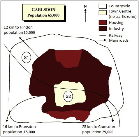
The map below is of the town of Garlsdon. A new supermarket (S) is planned for the town. The map shows two possible sites for the ...
The map below is of the town of Garlsdon. A new supermarket (S) is planned for the town. The map shows two possible sites for the supermarket.
图片

解题思路
【首段】总述地图显示超市选址S1S2 【二段】总述区别在于S2在城外,S2在城中心 【三段】分述S1和S2的地理位置 【尾段】分述到达S1和S2的交通方式
范文
The map shows two potential locations (S1 and S2) for a new supermarket in a town called Garlsdon. The main difference between the two sites is that S1 is outside the town, whereas S2 is in the town centre. The sites can also be compared in terms of access by road or rail, and their positions relative to three smaller towns. Looking at the information in more detail, S1 is in the countryside to the north west of Garlsdon, but it is close to the residential area of the town. S2 is also close to the housing area, which surrounds the town centre. There are main roads from Hindon, Bransdon and Cransdon to Garlsdon town centre, but this is a no traffic zone, so there would be no access to S2 by car. By contrast, S1 lies on the main road to Hindon, but it would be more difficult to reach from Bransdon and Cransdon. Both supermarket sites are close to the railway that runs through Garlsdon from Hindon to Cransdon.
参考题目8
The diagrams below show some principles of house design for cool and for warm climates.
图片

解题思路
【首段】总述图表显示根据不同气候有不同的房屋设计 【二段】总述最大不同是屋顶,然后是窗户和绝缘 【三段】分述在冷热气候里屋顶和绝缘设计的不同 【尾段】分述在冷热气候里窗户设计的不同
范文
The diagrams show how house designs differ according to climate. The most noticeable difference between houses designed for cool and warm climates is in the shape of the roof. The designs also differ with regard to the windows and the use of insulation. We can see that the cool climate house has a high-angled roof, which allows sunlight to enter through the window. By contrast, the roof of the warm climate house has a peak in the middle and roof overhangs to shade the windows. Insulation and thermal building materials are used in cool climates to reduce heat loss, whereas insulation and reflective materials are used to keep the heat out in warm climates. Finally, the cool climate house has one window which faces the direction of the sun, while the warm climate house has windows on two sides which are shaded from the sun. By opening the two windows at night, the house designed for warm climates can be ventilated.
- 03-27·2019年4月6日雅思写作小范围机经预测
- 03-25·2019年4月27日雅思写作机经预测
- 03-20·2019年4月25日雅思写作机经题目预测及范文
- 03-19·2019年4月13日雅思写作机经预测
- 03-18·2019年4月6日雅思写作小范围预测
- 12019-02-262019年3月9日雅思写作小范围预测
- 22019-02-122019年2月16日雅思写作机经预测
- 32019-01-262019年1月26日雅思写作小范围预测
- 42019-01-172019年1月19日雅思写作大范围预测
- 52019-01-172019年1月19日雅思写作小范围预测
编辑推荐
book.examw.com
-
 雅思9分之“听”为上策--新航道英语学习丛书¥39.00


- 模拟试题
- 历年真题